Challenges

The Challenges We Face

Two large challenges facing our region’s groundwater are shared use and quantifiable metrics to ascertain sustainability.


IMG 20190429 142544 Scaled

Shared use

People have coined the phrase, “groundwater knows no political bounds” and this is true. Consider the Memphis/Sparta aquifer underlying much of the embayment; thus, underlying portions of eight states. Used by cities & towns, industry and agriculture, how can this finite resource be shared equitably among its enumerable users and how can jurisdictions agree on shared management?

  • In 2004, representatives from federal agencies (U.S. Geological Survey, U.S. Army Corps of Engineers), state environmental agencies, local county government, and academia formed MAT-RAS (Mississippi-Tennessee-Arkansas Regional Aquifer Study) to begin discussions on shared management of the aquifer systems beneath these states. This pursuit failed when the State of Mississippi sued the City of Memphis and its largest utility, MLGW, in 2005, for stealing its groundwater.
  • A lawsuit brought by the State of Mississippi against the City of Memphis, Memphis Light, Gas and Water (MLGW), and eventually the State of Tennessee continued in various stages, reaching the U.S. Supreme Court twice until final judgement was made in favor of the defendants in 2021. Though parties were fighting over groundwater systems shared between these two states, the outcome has since defined the view of interstate aquifer systems nationwide as a shared resource, not owned by any one state. You can learn more about it here.
  • Completed State Water Plans exist for 3 of 8 embayment states. They address groundwater, surface water and other pertinent topics (e.g., recreation, infrastructure, legalities, etc.). Though individual to each state, comprehensive water plans from all embayment states would, in a regional sense, help address usage, availability, quality, protection, and conservation.

We need to prepare for future growth in our area because we are water rich. As other parts of the U.S. struggle with water shortages, their eyes will turn towards the Mississippi embayment. Consider the USDA estimation of irrigated agricultural land changes between 1997-2012. At least two large regions of the U.S. show an increase in irrigated land (this could be a proxy to available water) with one of these large regions in the Mississippi embayment. We need to support economic development in the region as well as address surface water and groundwater sustainability to know what we can accommodate with increased water demand.

1969 Graphic Summary LAND IN FARMS AND LAND USES 705 Table 13 Scaled
1974 Graphic Summary Land In Farms And Land Uses 436 Table 94 Scaled
1978 Graphic Summary IRRIGATION AND DRAINAGE 232 Table 93 Scaled
1982 Graphic Summary IRRIGATION 152 Table 91 Scaled
1987 Agricultural Atlas Of The United States IRRIGATION 52 Table 105
1992 Agricultural Atlas Of The United States 1587 Img 2
1997 Agricultural Atlas Of The United States Irrigated Land 1625 Table 02 1
2002 Ag Atlas Irrigated Land ChangeInAcreage Scaled
2007 Ag Atlas Maps Farms 07 M081 RGBDot2 Largetext Scaled
2012 Ag Atlas Maps Farms 12 M081 RGBDot2 Largetext Scaled
2017 Ags 30fe77f743be45f2af2d622644f44042 1 Scaled
vilalpando
Villalpando-Vizcaino, R., Waldron, B., Larsen, S., and Schoefernacker, S., 2021. Development of a Numerical Multi-Layered Groundwater Model to Simulate Inter-Aquifer Water Exchange in Shelby County, Tennessee, Water, v.13(18), https://doi.org/10.3390/w13182583

Quantifiable metrics

What metrics help us define groundwater sustainability? Let’s breakdown the definition of sustainability.

Defined as the use (withdrawals (pumping)), development (serving a purpose) and protection (not overdraw and maintain quality) of the groundwater resource at a rate (balance loss and gain) and manner (smart planning) that provides for current and projected needs (account for stressors (e.g., population growth, climate extremes, economic development/growth) without damage to the groundwater system or jeopardizing the ability to meet future water demand (computer modeling).

Each bolded item can be broken down further into quantifiable (measurable) data components. You can imagine the volume of data this would produce and furthermore realize the complexity of data interconnectedness (interplay, cause & effect). This is the value of computer modeling.

At the embayment scale, the U.S. Geological Survey has developed a comprehensive numerical model (MERAS) to address water availability and to a degree, quality concerns, for major aquifers. This model is dynamic meaning data are always being collected and the model is being refined to support smart planning and decision-making.

Models are also developed at local scales that can incorporate more detail than regional models. An example is the CAESER-I model for Shelby County that looks at groundwater withdrawal, inter-aquifer exchange, and the potential of contamination among its three primary aquifers. It is also a dynamic model. Data from MLGW, City of Bartlett, City of Germantown, Town of Collierville, and City of Millington support this model.

The Impact of Breaches

A huge effort is underway in Shelby County, paid for by its citizens, to investigate the impact of breaches in the upper confining unit to the Memphis aquifer from leakage coming from the shallow aquifer, which can carry contaminants with it. This 5-year, $5 million effort is being conducted by the University of Memphis’ CAESER in cooperation with MLGW, producing 25 deliverables (or projects) conducted by master’s and doctoral students.

Featured Project: Protective Clay Breaches

We have held three public forums since the project’s inception (June 2018) that describe project progress. Quantifiable metrics from these 25 projects support decision making and are incorporated into the CAESER-I model, thereby improving its ability to simulate groundwater conditions more accurately.

hero
Brian Podium Scaled
Back Of Room Video Playing Scaled
Front Side Scaled

A critical metric not well understood is groundwater recharge. Recharge is how much water naturally replenishes our groundwater through precipitation or from streams and other surface water features. If the aquifer is a box, we know how much water is in the box and we know how much is leaving the box (e.g., pumping), but we do not know what is entering the box (recharge). How can we determine sustainability without this critical metric?

Recharge

Recharge has been estimated from computer modeling (good estimate), yet the number of physical measures of recharge (best estimate) are few. For over 20 years, CAESER has been conducting field experiments to estimate recharge to the Memphis aquifer in Fayette County, TN.

For many years, funding was minimal. But in 2018, companies recognized the importance of this critical metric and allocated funding towards investigating recharge.

IP Logo
International Paper $500,000


The Chemours Company 8
Chemours $180,000

Hillside

IMG 1367
DSC01100
DSC01085
DSC00866

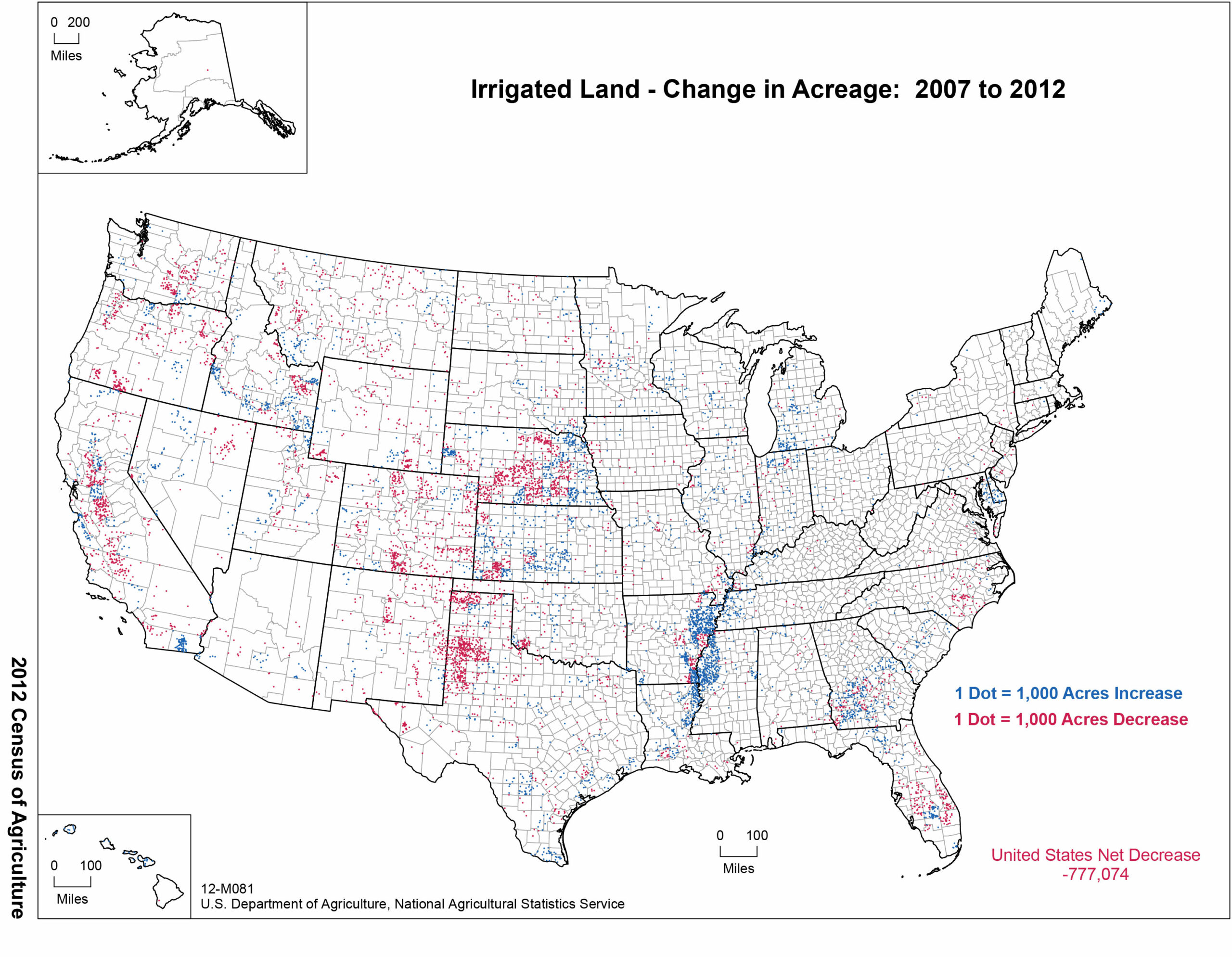
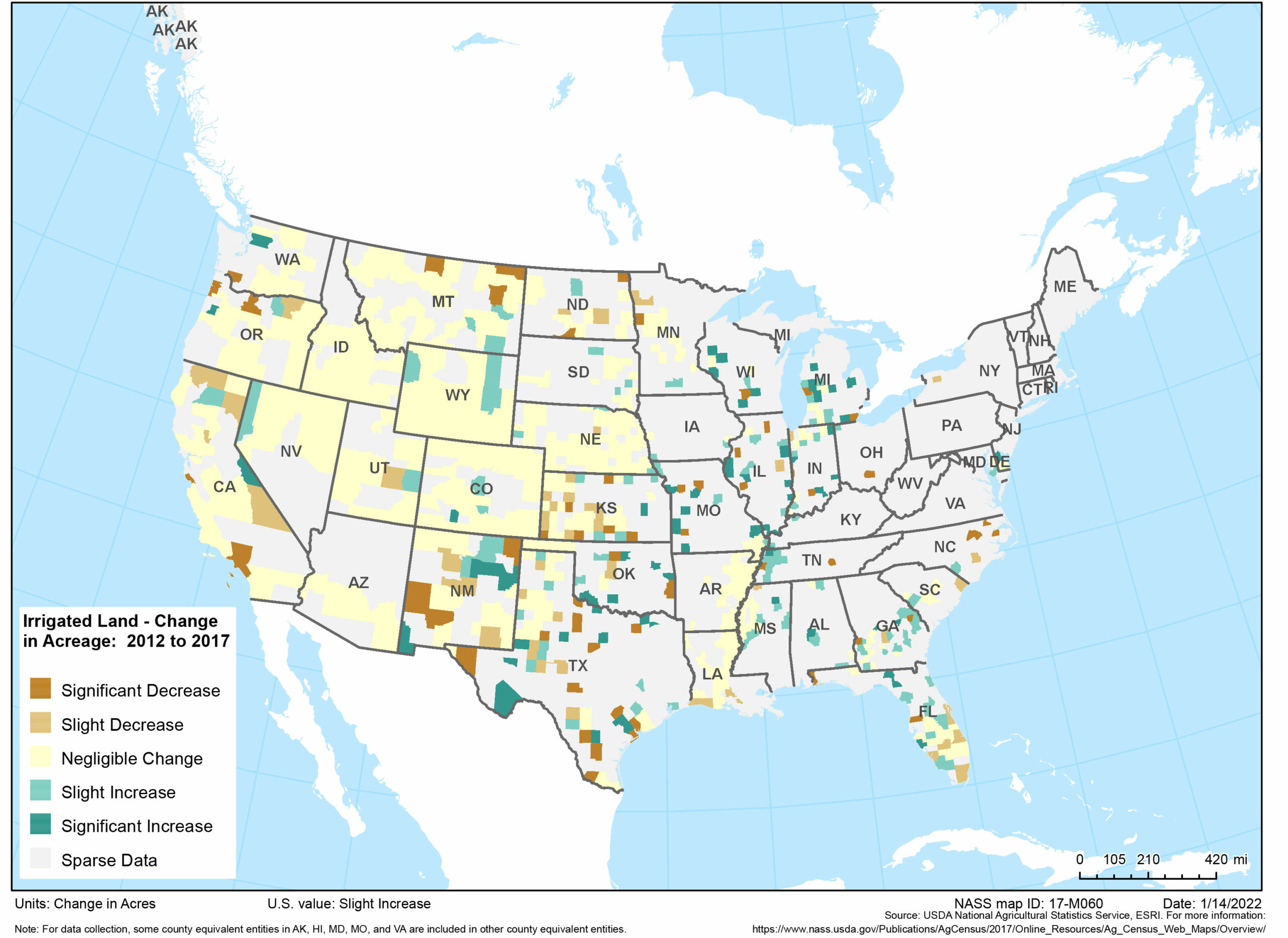
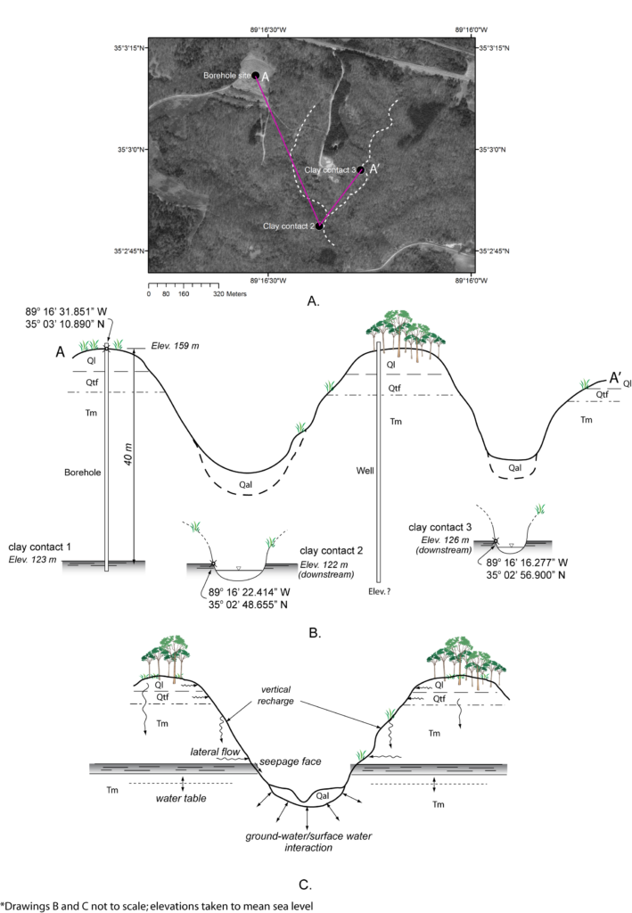
Other studies have also spawned to further understand recharge mechanisms.

West TN River Basin Authority

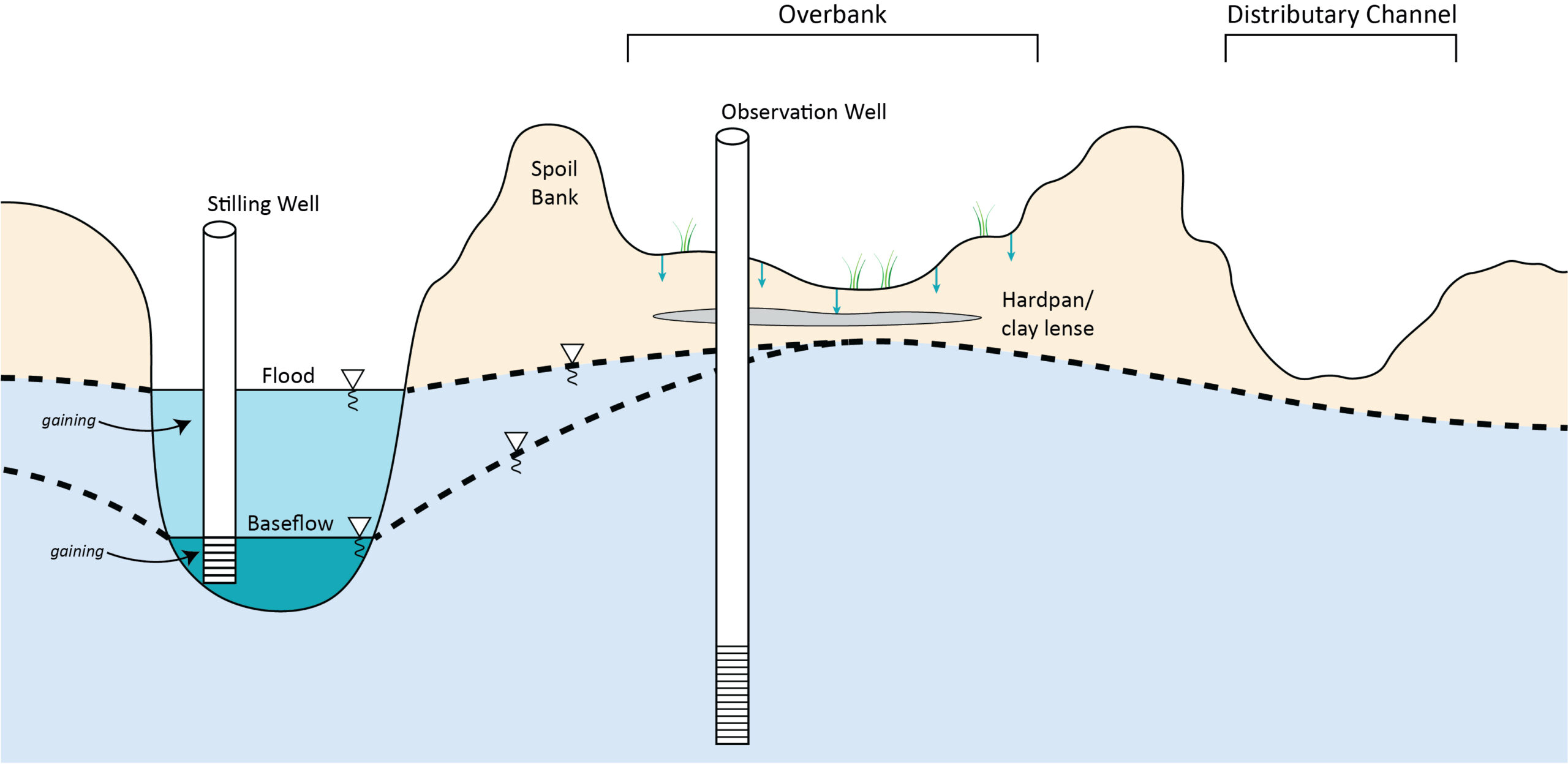
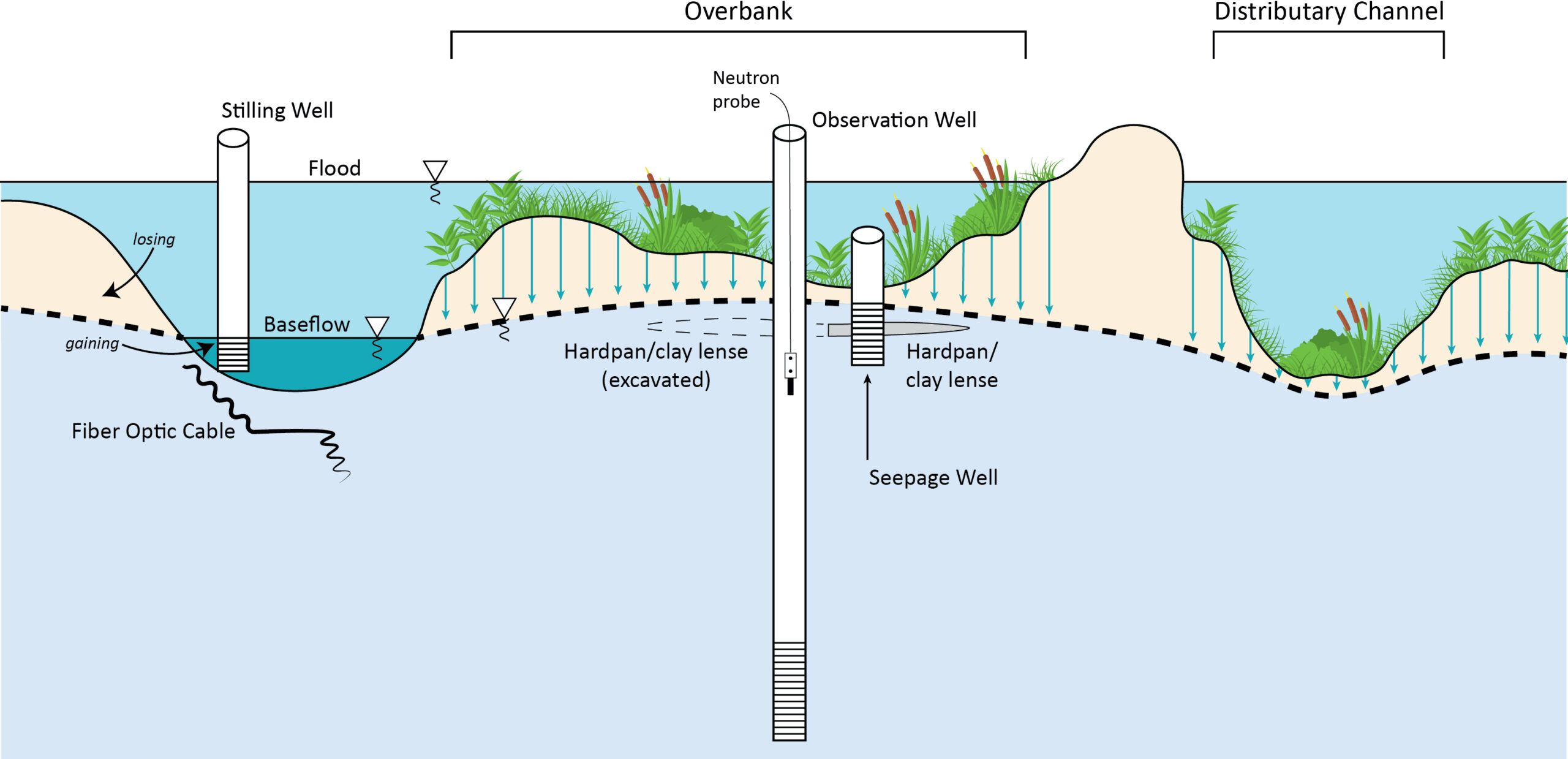
Incised streams in west TN have disconnected from their riparian zone; thus, lowering the water table and eliminating periodic flooding that induced aquifer recharge (see BEFORE). Repair of those streams back to a near-natural condition have the high likelihood of improving recharge potential to the aquifer (see AFTER). Three sites are under investigation: Sandy Creek and Muse Creek near Jackson, TN and Lone Oaks in Hardeman County, TN.

Before remediation of stream

Bugherdattachment Scaled

After remediation of stream

Bugherdattachment 1 Scaled

IMG 2679 Scaled

TN Dept. of Agriculture

With an aim toward understanding groundwater availability to west TN farmers, this effort also focuses on addressing 4 of the 10 recommendations in Tennessee’s water plan, TN H2O.

  • Establish monitoring well networks to measure groundwater levels to proactively evaluate trends in groundwater levels and impacts. Additionally, conduct simultaneous data collection proximal to the intersection of surface water and groundwater systems.
  • Determine recharge mechanisms and rates to the key aquifers in West Tennessee by precipitation, surface water-groundwater exchange and inter-aquifer exchange. Derive zones of protection based on critical recharge areas and contamination potential; consider possible designation as preferred sole source aquifer.
  • Obtain measures of groundwater usage for agriculture through a voluntary program with producers.
  • Develop TN Specific Educational Component on Groundwater. Focus on importance of groundwater in TN, groundwater protection and conservation, hydrologic process dependencies (e.g., recharge, surface/groundwater interactions with regional considerations), groundwater sustainability and contributing factors to include land processes, shared use, stressors, etc.