Real-time Water Levels
The real-time monitoring of groundwater and surface water levels provides critical data for water resource management. Groundwater and surface waters are intricately connected parts of the hydrologic cycle, with groundwater often feeding streams, lakes, and wetlands while also being recharged by them. Tracking water level fluctuations in real-time enables scientists, engineers, and policymakers to make informed decisions about water usage and identify emerging issues before they escalate.
For groundwater, real-time monitoring offers insights into changing aquifer levels and groundwater storage over time. Declining groundwater tables may indicate unsustainable usage rates or changes in recharge from precipitation and surface water seepage. This allows for proactive groundwater management, rather than reactive approaches once resources become depleted or contaminated. Understanding short and long-term trends in aquifer levels is key for balancing groundwater pumping with natural recharge rates.
Similarly, monitoring surface water levels in rivers, lakes, reservoirs, and wetlands helps detect availability issues early on. Water managers rely on up-to-date water level data to plan reservoir operations, allocate water rights, anticipate drought impacts, and issue flood advisories. Environmental agencies use the data to assess habitat health, water quality variation, and ecosystem changes over time. Real-time monitoring enables rapid response when water levels veer into alarming thresholds, which can mitigate environmental and socioeconomic impacts.
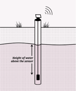
To measure groundwater levels we use a pressure transducer, which is a device that measures water pressure and converts that pressure into a water level measurement.
Imagine you are an underwater diver. As you swim deeper and deeper, you feel greater pressure on your body from the weight of the water above pushing down. Even without looking at a depth gauge, you can tell you are descending by how much squeezing pressure you feel.
A pressure transducer does the same thing. It has electronic sensors inside that feel and detect this water pressure. The deeper below the water surface the transducer is lowered, the more pressure is exerted on its sensors by the water above it. It continuously measures this pressure and converts the readings into feet, meters or other units to show the water level depth.
Surface water monitoring
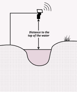
We use non-contact ultrasound sensor to detect the change in surface water levels. These sensors send out very high-frequency sound waves that are beyond what humans can hear. When those ultrasonic sound waves hit and bounce off the water surface, they reflect back to the sensor, much like how your voice echoes back when you yell towards a mountain or tall building.
Inside the sensor is a timing device that measures how long it takes for the sound waves to leave the sensor, bounce off the water, and then return back again. Because the speed of sound through air is a known constant, the time of this sound “round trip” can be used to very precisely calculate the distance between the sensor and the water below it. If the water level rises, the distance becomes shorter. And if the water level drops, the time and distance measured becomes longer.
Sites with real-time monitoring devices
![]() Click on this icon below to display the symbology and the site names. Click on individual pins to show the site information and the access link to the real-time data.
Click on this icon below to display the symbology and the site names. Click on individual pins to show the site information and the access link to the real-time data.